ORDINANCES:
Unified Development Ordinance (includes amendments made through 1/18/24) - The Unified Development Ordinance (UDO) governs land use and development throughout the City of Monroe planning jurisdiction. City Council adopted the new UDO and Zoning Map on April 12, 2022 with an immediate effective date.
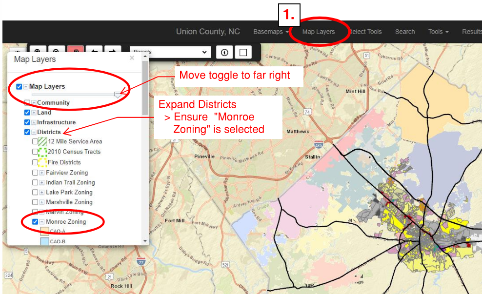
Union County Go Maps has the City's new zoning as adopted in April 2022. While the County information may be correct in most cases, it may not reflect map amendments as they occur. For up to date information, please contact City Planning staff.
https://gisweb1.unioncountync.gov/gomaps/
Concord Avenue Overlay District Ordinance (effective May 2, 2017)
—————————————————————————————————————————
REGULATIONS:
Historic District Standards- The Historic District Standards were adopted in September 2019. In August 2021, the Historic District readopted the The Design Standards in order to comply with Chapter 160D of the North Carolina General Statutes with an effective date of August 10, 2021. The Standards are used by the Historic District Commission in reviewing the appropriateness of proposed changes in the South Monroe Historic District.
—————————————————————————————————————————
ADOPTED PLANS:
Future Land Use Plan and Transportation Plan- (adopted 2018) Click here for the complete document
Forward Monroe is the city's blueprint for development, its growth strategy, and the foundation upon which future land use and transportation decisions will be based. The plan responds to existing challenges, anticipates future needs, and prepares the community to accommodate future growth. The plan will guide future city-wide plans, small area plans, land development regulations, capital projects, and other programs and services.
Concord Avenue Area Master Plan Click here for the complete document
The purpose and intent of the Concord Avenue Area Master Plan is to improve the aesthetics, safety, viability, and appeal of the Kerr Street area through a comprehensive small-area redevelopment plan.
The goals of the project include developing new and improved housing stock, creating economic development and employment opportunities, revitalizing properties to create an attractive entrance to Monroe, and establishing a catalyst area for improvement.
Special objectives of the plan include: 1. Developing a plan that addresses urban design, future land uses, aesthetics, and transportation that would reflect the vision of the community and drive a positive image for the area. 2. Developing a plan to serve as a gateway node for downtown Monroe and a catalyst for future projects. 3. Developing an action/ implementation plan that will provide implementation strategies, including a list of catalyst projects, phasing plans, available funding sources, and agencies responsible for implementing the vision
Downtown Master Plan Click here for the Complete Document (effective 2008) Downtown Master Plan Summary Poster
The Downtown Master Plan was adopted in February 2008 and reflects a vision for a place where people live, work, and play and where restaurants, entertainment venues and shops enliven a safe city core. The purpose is to serve as a guide for future development in the downtown area, counteract the impact of lost retail, revitalize the historic core, and make Downtown Monroe an exciting destination.
Downtown Master Plan Maps Context Map Study Area Map Assets Map Block Pattern Map Existing Land Use Map Transportation Map Transportation Map 2 Open Space and Greenways Future Land Use Map